The 11 best Lake District mountain bike routes

The Lake District is home to some pretty impressive (and challenging) mountain bike routes.
In fact, as England’s most mountainous region, it’s arguably one of the best places to go mountain biking on these shores. But most Lake District mountain bike routes certainly aren’t for the faint-hearted, as they can often present real challenges for cyclists.
However, the rewards (and views from the hills) are rather spectacular if you’re up to said challenge. From nearby Penrith in the north, stretching down to the small town of Millom in the south, the Lake District is a mountain biker’s paradise.
And whether it’s a long or short trail you’re after, we’ve got you covered. In no particular order, here are 11 of the best Lake District mountain bike routes.
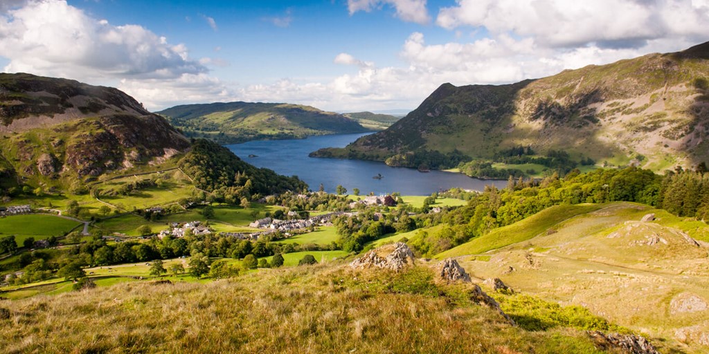
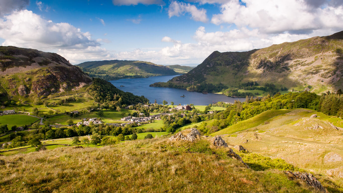
Helvellyn
Region: Glenridding, Eastern Lake District
Distance (approx.): 13 miles
More info on the route here
We start our trail on a mountain—naturally. But not just any mountain…
Helvellyn boasts the third-highest point not just in the Lake District but in the whole of England, and this specific 13-mile mountain bike trail takes on the country’s highest bridleway, too.
Starting from the Ullswater Information Centre in Glenridding, this route climbs more than 3,000ft. over Sticks Pass before descending Dolywagon Pike and Grisedale.
This route is certainly for the more experienced mountain bikers among us. With various steep descents and a few ‘hike-a-bike’ sections thrown in for good measure, Helvellyn is one of the Lake District’s most challenging mountain bike routes.
But it’s also among the most rewarding if you can make it to the top, as the views are incredible—especially in summer.
Related: Hike-a-bike—how to carry your bike on the trails
Muncaster Fell
Region: South-Western Lake District
Distance (approx.): 10 miles
More info on the route here
Muncaster Fell is far less physically demanding than Helvellyn, even despite its 2,100 ft. ascent.
This somewhat ‘gentler’ mountain bike route in the south-west of the Lake District is suitable for all the family, children included, making it a perfect day activity if you’re holidaying nearby.
The fell itself is a narrow ridge of land, measuring just 1.2km wide, lying between the River Mite in the north and River Esk in the south.
Muncaster also boasts a historic castle and gardens of the same name, which you’ll find at one end of the route. You’ll also find the famous Ravenglass and Eskdale Railway, or ‘La’al Ratty’, as it’s known locally. This is one of the oldest and longest narrow gauge railways in England.
Lake Windermere
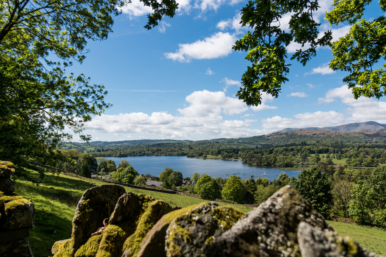
Region: Windermere, South-Eastern Lake District
Distance (approx.): 7 miles
More info on the route here
This route follows Lake Windermere’s western shore, beginning at Harrow Slack and finishing at Wray Castle in Ambleside.
At roughly 7 miles long (one way), it’s another perfect mountain bike route for families, not least for the blissful picnic spots along Lake Windermere—the largest natural lake in the Lake District and indeed all of England.
For fans of children’s books, there’s even an opportunity to see Beatrix Potter’s farm and former home, Hill Top, in Near Sawrey along this lakeside route.
You’ll also find great variety in the terrain around this part of the Lake District. Some sections of this route involve stunning woodland areas with a mixture of steep and short climbs. You’ll be kept on your toes, for sure.
Coniston Water
Region: Furness, Cumbria
Distance (approx.): 20 miles
More info on the route here
Lying west of Windermere is Coniston Water—the third-largest lake in the Lake District by volume (and fifth-largest by area). Although only five miles long, there are some pretty hefty mountain bike routes around its outer.
This 20-mile trail, in particular, treats cyclists to some of the most stunning views in the Lake District by far.
From Coniston, cyclists first climb south-west onto the Walna Scar Road before approaching the civil parish of Torver and, later on, the outskirts of Grizedale Forest.
Coniston Water is also home to the Old Man of Coniston, the highest point in the Furness Fells at 2,635ft. If you’re sticking around for a while, this can be walked in around 2-3 hours, too. Maybe not on the same day as your cycle, though!
Whinlatter Forest
Region: Allerdale, Cumbria
Distance (approx.): 12 miles
More info on the route(s) here
There’s just something about forests that makes mountain bikers tick. Whether it’s the steep climbs or testing terrain, mountain bikes and forests go hand in hand.
Whinlatter Forest Park, on the outskirts of Braithwaite, is home to the longest purpose-built mountain bike trail in the Lake District.
There are various trails here with ranging difficulty levels catering for a wide variety of cycling abilities. The Altura Trail, in particular, is built for experienced mountain bikers with a solid base fitness and good stamina.
Cyclists are tested on this route, to say the least. There are various single-track sections that pose a challenge with features including berms, jumps and corkscrews.
Rest assured, it’s all worth it, though, as the views are spectacular. Cyclists can reach altitudes of 500m on this route with stunning scenery across Derwent Water and Helvellyn.
Whinlatter Visitor Centre, beside Bassenthwaite Lake, also boasts brilliant osprey viewing points via its Osprey Watch.
Ullswater Lake
Region: Penrith, Northern Lake District
Distance (approx.): 8 miles
More info on the route here
Ullswater Lake is the second largest in the Lake District, and this route is renowned for being one of the most technical but rewarding mountain bike routes in the UK.
Although 8 miles may seem fairly low compared to other similar routes, this looped trail shows off one of the Lake District’s most picturesque spots before spiralling off into what seems very much like the middle of nowhere. If you like escaping the crowds, this is the route for you.
The route can be done in either direction. However, by travelling from south to north, you’ll experience the challenging rocky descent to Silver Point, passing Silver Crag and Birk Fell, before one major adrenaline-inducing descent back down to Ullswater from the Boredale Valley.
The views, again, are incredible.
Walna Scar
Region: Grizedale, Southern Lake District
Distance (approx.): 22 miles
More info on the route here
Walna Scar is a 2,035 ft. hill not far from Coniston Water.
This mountain bike route is just over 22 miles long, starting from the small village and civil parish of Torver. The route is known for getting progressively harder as the miles go on, with high fells and large rocks following its navigable single-track start—so pace yourself.
Walna Scar itself is by no means a small feat. Anyone that’s ridden this route will know it’s one beast of a climb, but the descent from the summit is well worth it.
It’s worth noting you can also climb Walna Scar from nearby Duddon Valley, too. Both this and that route meet at the top pass of the famous Walna Scar Road, referenced in Andrew Young’s 1939 poem, The Thunderstorm.
Witherslack
Region: Witherslack, South Cumbria
Distance (approx.): 7 miles
More info on the route here
This Witherslack trail is one of the child-friendliest Lake District mountain bike routes, and it’s a good ‘Plan B’ to have should the weather mean you need to avoid the higher peaks.
The route, beginning in the small village of Witherslack, features a good mixture of charming woodland, limestone cliffs, and a rapid descent on rather rooty ground.
You’ll want to keep your eyes well peeled on this route, as the first intriguing landmark is merely ten minutes in. A rare tufa waterfall will appear on your right, caused by the slow flow of calcium carbonate from the stream above.
Tufa waterfalls are normally found in Africa and are different from other waterfalls in that the calcium-rich water helps rebuild the rock face over which it flows, often forming beautiful patterns.
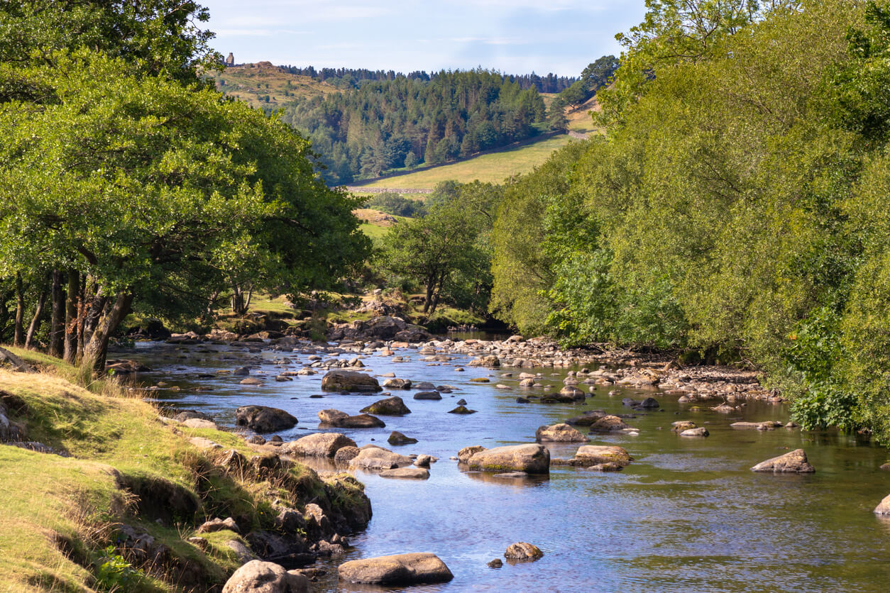
Duddon Valley
Region: Southern Lake District
Distance (approx.): 13 miles
More info on the route here
This 13-miler through Duddon Valley ticks all the boxes and then some, with its three main descents ranking among some of the finest the Lake District has to offer mountain bikers.
The peaceful River Duddon flows through the valley, rising in the mountains north of this route between Eskdale and Langdale before meeting the Irish Sea near Broughton-in-Furness in the south.
This route entails around 2,800 ft. of ascent, with cyclists heading south from the honesty-box car park at Broughton Mills to begin before heading towards Ulpha and then further north to Seathwaite.
If you’re old-school and like to refer to Ordnance Survey maps for your trails, it’s important to note that Ulpha is often labelled ‘Dunnerdale’—don’t get caught out!
The route then culminates with a loop back down towards the starting point.
Black Combe
Region: Copeland, South-Western Lake District
Distance (approx.): 9 miles
More info on the route here
For a relatively short route, Black Combe packs an almighty climb. In fact, 2,345ft. of ascent in just under 9 miles makes it one of the steepest mountain bike routes in the Lakes.
However, it’s an easy enough route to follow even despite its testing climbs. The route lies close to the south-west coast but provides a full mountain experience nonetheless.
After starting with a quick road section, the only way is up. The Black Combe mountain bike route is basically one extended climb—first on track, then onto an even steeper mixed bridleway.
The views on the climb make it all worthwhile, though, and you can even make out the Isle of Man on the horizon on a clear day.
The soft-ground descent is equally tough but nothing you won’t be used to by the time you reach it.
Caldbeck Fells

Region: Allerdale, Cumbria
Distance (approx.): 20 miles
More info on the route here
Frequent visitors to the Lake District will know that the northern regions often feel somewhat more remote compared to the southern side. And despite a few road sections, this particular route through Caldbeck Fells certainly substantiates that.
Caldbeck and its surrounding remote villages are full of old mining tracks, which form the basis of many of the mountain bike routes in the area—this one included.
Cyclists should head north from Mosedale in the direction of Calebreck, where you can head west atop the old mining tracks and towards Caldbeck.
Caldbeck itself is well worth a visit if you prefer secluded settings—not least because the entire village population is around 700.
Specialist mountain bike insurance from Cycleplan
There are some truly stunning mountain bike routes in the Lake District—but of course, none of them come without their share of risk.
Mountainous terrain is full of hazards for cyclists, and accidents are not uncommon. That’s why you should consider taking out specialist insurance to give you that much-needed peace of mind.
At Cycleplan, the specialist mountain bike insurance covers your bike for accidental damage up to the value of £30,000 and also includes Public Liability should you be involved in an accident.
Click here to learn more about Cycleplan’s specialist mountain bike insurance and get a bespoke online quote today.
Related
The 7 best cycling holidays in the UK
9 safety tips for mountain biking
The 9 best cycle routes in Wales
Please note the information provided on this page should not be taken as advice and has been written as a matter of opinion. For more on insurance cover and policy wording, see our homepage.